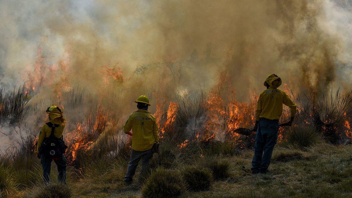
A column of smoke draws a line in the sky and the radios are activated. As if it were a starting signal, equipped from head to toe, a group of 10 brigade members climb in a van that will drive towards the hills. There, where smoke turns into a haze of heat and fire roars as it devours leaves and trees, controlling a fire is a coin in the air.
When fire touches a branch it can be for better or for worse. On the one hand, it could be an accident that for days devastates hectares equivalent to burning football fields. On the other hand, it could be a fire of natural causes, where flames will flow from the mountains to the valley to incinerate still life and leave the trees ready to be reborn.
Managing these two sides of the fire is the challenge for those who prevent and fight fires in Mexico.
Forest fires have devoured the country's forests more intensely in the last decade and are on the rise. The National Forestry Commission (Conafor) estimates that 2022 was one of the most critical years with 739 thousand 626 hectares affected.
Without knowing borders or decrees, fires occur in National Parks and Reserves that are Protected Natural Areas (ANP): The Sepultura in Chiapas, La Primavera in Jalisco, the Zempoala Lagoons in the State of Mexico, Centla in Tabasco and Sian Ka'an in Quintana Roo. Mostly fires caused by human activity.
In terms of extension, if we were to divide the more than 855,000 hectares of ANP burned during the last 10 years, every half hour the fire set fire corresponding to the esplanade of the Zócalo in Mexico City.

The Flames of the West
“The problem with fires? Yes, it has grown,” says Omar Haro, a community brigadier in La Yesca, in Nayarit, western Mexico. A town with a landscape full of pine and oak forests, but also of aridity, scrub and pasture. As a region located in the south of the Sierra Madre Occidental, here are parts of the Sierra Pajaritos, Sierra los Huicholes, Sierra Morones and other mountain ranges.
“There was a season where we only had one fire, but last year we had more than 20, they were forest fires. In addition, there were those of conatos, those that are pastures and undergrowth”, describes the brigadier and pauses to look for the details of this year's fires.
Your record is in the notes of a notebook and in a mobile application with data such as coordinates and altitude.
The most recent fire at the time of the press release of this article was on April 28, in the town of Cebolletas. There is also another one registered before, on the 14th of that same month, in the Sierra de Pajaritos, 122 kilometers from the municipal seat. Both are classified as a “high priority zone”.
“It means that they require immediate attention because of the type of forest and the fauna they have,” explains Haro. This is his fourth fire season in the town of Puente de Camotlán, during which time he has also been sent to the municipality of Nayar and the neighboring state of Jalisco. He has been so involved that last year he was able to integrate himself into firefighting in Oregon, United States.
For the brigadier, fires are increasingly voracious. “The season has gotten much more aggressive,” he says. In the Tinder, most of the time they are linked to burns for harvest that get out of control. However, Haro also mentions that those linked to the planting of marijuana are reported as illegal activities.

Between its pine forests and scrub areas, La Yesca has a diversity that a large part of its territory lies in the Feeding Basin of the National Irrigation District (CADNR) 043 State of Nayarit. A type of protected area of which little is known, but which was decreed since 1949 by the then president Miguel Alemán and recategorized in 2002 as a Natural Resources Protection Area.
CADNR 043 covers an area of 2,329 hectares. It is so large that it is distributed in four municipalities in Aguascalientes, 30 in Jalisco, five in Durango, 16 in Nayarit and 22 in Zacatecas.
But, despite its extension and variety of ecosystems, it does not have a current management plan. On the contrary, drought and the presence of crop burns, mainly corn, have made this ANP one of the most vulnerable to forest fires in terms of extension.
In a request for information made by Journalism CN for this report, the National Forestry Commission (Conafor) reported that during 2022, CADNR 043 State of Nayarit had the largest number of hectares burned, with more than 39,000 hectares. The surface area is equivalent to 36 soccer fields.
This is followed by Papigochic with 12,403 hectares and Tutuaca with 16,588 hectares, in Chihuahua; the Laguna de Términos with 10,417, in Campeche; and the CADNR Don Martín with 11,691, in Coahuila.
It is important to specify that the information on the surface refers to the burned area, which may have different levels of damage. In addition, the hectares burned are not always proportional to the number of fires. For example, in 2022, the State of Mexico ranked as the entity with the highest frequency of these accidents, registering 707 -unlike 145 in CADNR 043-, but most of them did not exceed 10 hectares.
At the national level, fires within protected areas have also increased in frequency and the extension of hectares. While in 2013, 856 were documented with the burning of 46,616 hectares, by 2022 the figure reached 2,222, reaching 183,776 hectares. The increase in incidence between these years is 160% and in surface damage of 294%.
At the local level, it should be added that just a year ago an Environmental Coordination was created by the City Council of La Yesca.
“The current municipal presidency was certain to open this Department of Environment because historically this area was not available. We are generating information on which species are the priority ones and where they are, in order to be able to attend to high-incidence sites in a timely manner,” explains biologist Christian Eduardo Hernández Franco, who is the new head of this area.
During the interview, Hernández Franco points out that La Yesca at the state level is one of the “least explored areas in terms of biodiversity”. Taking action has meant starting from scratch. Remember that when the Environmental Coordination began working, only basic information was available, such as soil characteristics and the record of two types of mammals.
A similar situation occurred with Civil Protection of La Yesca.
“When we started, I asked for a five-year history to think of an ideal care strategy, but they told me that the previous four years, fires were not being treated. They were served by the same people from the ranches,” shared Armando De La Cruz, who is the coordinator of the mechanism at the City Council level.
Both agree that since there is no complete local record of fires, it is difficult to know the priority areas, as well as the historical impacts, linked to other problems in the region such as drought and water scarcity.
“One of the main consequences that has occurred is the loss of water collection. For example, there is a drinking water outlet for one of the larger towns called Puente de Camotlán. This shot came from the Sierra de Pajaritos, but there was a fire last season that we reviewed later due to scarcity and, in fact, it's almost dry,” says biologist Hernández Franco.

Fire, a layered onion
One of the reasons why measuring the impacts of fires is a complex task is because, according to Conafor's practical guidance, in a country like Mexico, burned surfaces correspond to ecosystems that depend on fire.
In regions such as the west of the country, where pine and oak forests abound, the burning of nature is part of a natural process. Fire doesn't always cause destruction and damage. These types of ecosystems are adapted and their trees regularly have thick and insulating bark, with foliage that recovers.
However, the lack of adequate management to prevent disastrous fires and help to have controlled burns is what is causing the damage. Conafor itself points out that 99% of fires are caused by human activities.
Agricultural burns and illegal or intentional activities top the list of causes, exceeding 50%, according to information provided via transparency to Journalism CN. Added to this are less common, but also constant, the burning of garbage dumps, smokers, bonfires and hunting.
“The increase in fires is a combination of factors. We cannot talk about just one because they are a complex topic... it's like an onion that has many layers and we cannot reduce it to just one, because in addition, the territories in our country are varied. You have forest cover very close to an agricultural area, followed by a park or protected area...”, explains Michelle Farfán, PhD in Geography and professor in the Department of Geomatic and Hydraulic Engineering at the University of Guanajuato.

“At the same time, we have larger fires because there is more fuel that can fuel them due to the effects of climate change. There are very dry periods because we have constantly experienced the La Niña phenomenon, which intensifies droughts and makes fires more intense,” adds Dante Rodríguez Trejo, doctor in the Forest Sciences Division of the Chapingo Autonomous University.
In addition, both specialists agree that another problem with fire management has been the loss of knowledge provided by communities in Mexico. All this in the midst of the lack of budget and necessary resources for brigade members and environmental institutions.
In La Yesca, where only in the last year there have been more efforts, brigadier Omar Haro recalls that “it used to be handled in a very rustic way. They just gave you your tool, your shirt and your helmet. The basics.”
In the information provided via transparency to Journalism CN, Conafor indicated that the financial budget paid for the National Forest Fire Protection Program in 2023, a little more than 726 million pesos were authorized. This is lower than the amount exercised in 2022, which exceeded 908 million and in 2021 with 945 million.
The budget has remained similar in recent years, even with the increase in forest fires. Organizations such as Greenpeace have pointed out that decisions such as canceling the Temporary Employment Program (PET) in 2019 have made it difficult to finance brigades to carry out work, as well as the decision to eliminate the Natural Disaster Fund (Fonden).

Despite the voracity that fire can have, removing it from nature and reducing forest fires to zero is not the way to go. The most feasible thing, according to expert voices, is to regulate the human agents that alter the process.
In the search for solutions, researchers such as Dr. Farfán have worked with spatial models to identify fire patterns. Places such as La Yesca are making progress at the local level with campaigns in schools, training for community brigade members and the generation of information through tools that already exist in Conafor, such as the detection of hot spots and dynamic maps.
Finally, beyond the technology and the outstanding debts of the authorities, for Omar Haro, as a brigadier, it is important to make forest fires an interest of all people.
“In the brigade, we do preventive activities such as guardrails, which are openings in the ground, but within a week they fill up with garbage and are erased. Conafor asks us to do a lot of these, but what we also need is people's awareness,” he says.

Comentarios (0)