Mexico has 905,86 hectares of mangroves, revealed the recent publication of the book “Mangroves of Mexico, Update and Analysis of Data 2020” by the National Commission for the Knowledge and Use of Biodiversity (Conabio).
Although the area represents an increase of 129,531 hectares compared to the hectares of mangroves identified in 2015, Causa Natura interviewed the president of the Mexican Mangrove Committee, Jorge López-Portillo, to put the information into perspective.
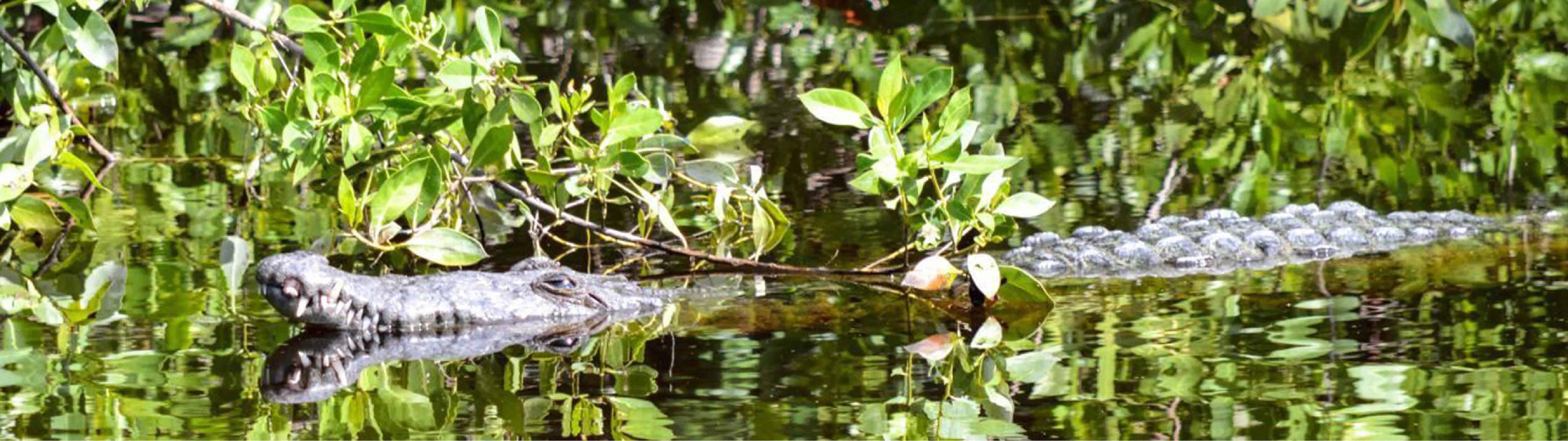
The researcher also the Institute of Ecology (Inecol) highlighted the importance of the complaint to preserve mangrove ecosystems, which in addition to being a source of oxygen, home to various species and serving as buffers against high tides, help to counteract effects derived from climate change by having more capacity to store carbon than other tropical forests.
Mexico represents 6% of mangroves in the world, making the country the fourth country with these ecosystems after Indonesia, Australia and Brazil, according to Conabio.
— Only 76% of the hectares of mangrove forest that existed in the 70s and 80s are preserved. According to the Conabio book, initial mangrove areas continue to be lost at a relatively constant rate. Why?
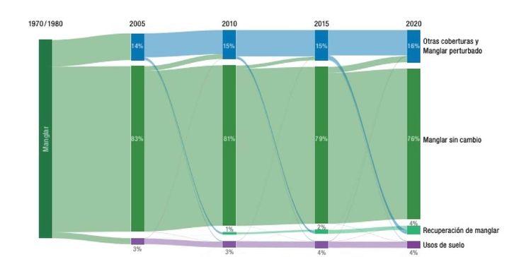
Flowchart on changes in mangrove surface in the book “Mangroves of
Mexico, update and analysis of
data 2020”. Credit:
Conabio
There are several issues, when industrial, urban and tourist development is near, mangrove areas are sometimes disappearing, or infrastructure is simply established to carry out that development and that infrastructure begins to block waterways. Mangroves live between sea and land. Between the contribution of continental water, rivers, groundwater, and the supply of the sea. And it's in that mix that mangroves grow. When you have one or the other, it affects the mangrove.
So there are direct and indirect causes. In short, the direct causes have to do with deforestation, because they want to expand a city, a pasture, and then they disassemble the mangrove. Those are direct. And there are indirect causes where you basically interrupt hydrological flows. Or they block the mangrove everywhere, and then since there is no exchange of water, the mangrove dies.
— Does it always happen like this?
For example in Tajamar. That mangrove forest that was there and they built everything around. It was an urban project that was simply postponed and made benches, almost everything. But there in Quintana Roo what happens is that we have a calcareous environment, and there is beginning to be erosion through underground channels, the flow of groundwater. And then that mangrove never died, but through underground flows it fed and eventually became a natural park, where people went for walks, to run, to visit the pier that is there. And then what we know happened later. All this is to say that sometimes, even if roads are put in place and everything, the mangrove is not affected, but the areas where there is the most mortality are because hydrological flows are interrupted by the laying of roads and not enough water passes through them or because a hurricane passed and blocked the water exchange routes and the mangrove died.
— Although mangroves are protected by the General Law on Ecological Balance and Environmental Protection, why did we see ecocides like the one in Tajamar? What needs to be tackled so that they don't happen?
In this case, the public reaction was overwhelming, and the destruction of the mangroves stopped. The case of Tajamar is interesting because the infrastructure was already there, there were streets, sidewalks, services, only buildings were missing, but it just wasn't done. And as it turned out, Tajamar became a natural park. Then there comes a time when yes, you wait too long to make a development.
Now I think that the permissions that were given back then would no longer be given. We are thinking of the 70s when Cancun was just beginning. Back then we didn't have the consciousness that we have now.
— Returning to the book presented by Conabio, it is said that in 2020 the total area of mangroves in the country amounted to 905,86 hectares in 17 coastal states. This represents an increase of 130,000 hectares compared to 2015, but it is largely due to the reclassification of areas that were classified as “other wetlands” and to the sum of 80,000 hectares of the Sian Ka'an biosphere reserve in Quintana Roo. How far have wetlands really spread?
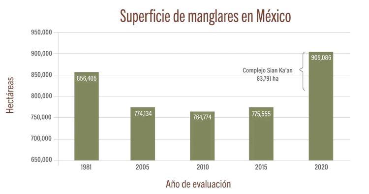
Conabio elaboration. Source: Conabio in the Mangrove Monitoring System of Mexico
(SMMM)
We have an evolutionary process, of remote image processing, which are increasingly accurate. The way in which the areas were determined in the 70s and 80s were aerial photographs taken by Aerofoto or by Inegi (National Institute of Statistics and Geography) [...], but even later when Conabio committed himself to this, it was because he had access to these SPOT 5 satellites [...], so with the Spot 5 images it was not as clearly seen as now with those of the Sentinel-2 satellites, which are much clearer.
Now, anyway, that doesn't take my finger off the line about how much is so much. What can be seen in the images is that the density of mangrove trees there that are surrounded by other types of vegetation, such as pastures, are what give to the shrub mangrove, which can be 80 centimeters or two meters high. So there you have to make the decision if that is already a mangrove or not. In other words, what is a mangrove, something that has 100% coverage with trees 40 meters high as in Chiapas, or these 2 meters high and that are 3 or 4 or 5 meters apart, from each other.
Once that definition was taken, finally this area, which was already in the category “other wetlands” in the case of Sian Ka'an, is a mixture of those mangroves and those pastures, but now with a better resolution, the decision was made to integrate it.
But that's only part of it.
— What's the other part?
There is another part that is distributed throughout the republic. That can be seen very well in the book. Let's say that Conabio's work is a heroic thing, but now it's up to people in states that have mangroves to try to distinguish what was already there that Conabio detected, and what increased.
In Tecolutla, with images from Google Earth, you can see how the mangrove is expanding. And I am sure as I am seeing it in Veracruz there are others seeing it in other parts of the republic. And this has to do with two issues, the first is the rise in sea level. Every year, what is, like tradition, is that there is an increase of one millimeter per year.
But with climate change, these increases may be greater. And then when sea level rises and we are on a plain this means that much more seawater will enter and that mixture of fresh and salt water will be more extensive and that will facilitate the advancement of mangroves inland.
On the other hand, there is also the fact that there may be sediment deposition in places where there was no depth before and once sediments are deposited, the mangrove can settle there.
— 60% of mangroves are found within Protected Natural Areas in Mexico. What should be done? , extend the Areas to protect them?
How good that more Protected Natural Areas are being built. What interests me is this concept of the Biosphere Reserve, which has a Mexican modality, which is that there are buffer zones where people live with mangroves, respect them and know them.
I wouldn't bet everything that where there are mangroves make a natural area, because we see mangroves with very few hectares. So are we going to make an area to protect that mangrove? , better to seek that the entire community around them is committed to conserving.
So for protection as a Natural Area, what we have is fine, if only it could increase. What worries me is that because a mangrove forest is not in a natural area, it is not protected. That is the commitment that must be had at the national level, that whoever lives near a mangrove will protect it, the only way you can protect it is by knowing it.
— What role does reporting play in protecting mangroves?
There have to be complaints, sometimes they use mangroves from garbage dumps, they burn, and you have to report, because mangroves are in a federal zone, the definition of a federal zone has to do with the idea that they are flooded areas, a mixture of salt and fresh water. In the reservoir area, it is a federal zone and is owned by everyone, and what belongs to everyone belongs to no one, the famous conflict of the communes. If we take care of that, it would be the maximum protection that can be given.
The Profepa (Federal Attorney's Office for Environmental Protection) does not have the capacity to rely on personnel, citizens have the moral obligation to raise a citizen's conscience and file a complaint and that these complaints allow those who dare (to damage a mangrove) not to dare.

Comentarios (0)