Through the analysis of satellite data, an ultra methane emission event has been detected on a Petrleos Mexicanos (PEMEX) platform in the Gulf of Mexico, defined by the emission of pollutants beyond the normal operating criteria of these platforms. According to the PEMEX emissions inventory, the energy sector (transportation, power generation, oil and gas, manufacturing and construction industry, and others) continues to be the main source of greenhouse gas (GHG) emissions in Mexico.
Methane is the second most abundant anthropogenic greenhouse gas after carbon dioxide, but it is 25 times more potent than carbon dioxide in trapping heat in the atmosphere. Mitigating emissions from the oil industry is one of the most effective ways to curb global warming.
In a recent study published in Environmental Science and Technology Letters, a team, led by scientists from the Universitat Politècnica de València (UPV), used data from the WorldView-3 and Landsat - 8 satellite missions to detect and quantify methane emissions from a PEMEX offshore oil and gas production platform near the coast of Campeche, in one of Mexico's main oil-producing fields. The site analyzed in the above-mentioned study is associated with the Zaap-C platform for offshore oil and gas production in one of the most important oil fields in Mexico.
The results show that the platform intermittently emitted significant amounts of methane during the 17-day ultra emission event with an estimated amount of 40,000 tons of methane, equivalent to 3.36 million tons of carbon dioxide released into the atmosphere in the period from December 8 to 27, 2021 with breaks on the 16th and 17th. These emissions are equivalent to around 3% of annual oil and gas emissions at the national level and this unique event would have a magnitude similar to the emissions generated annually in the region.
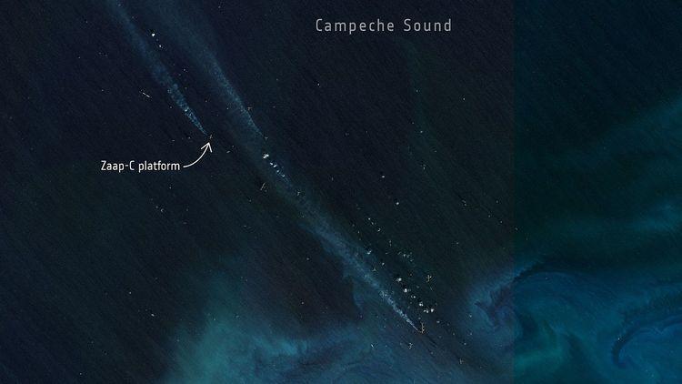
The satellite image published by the European Space Agency. Photo: esa.int
The team associated with the Directorate of Earth Observation Programs of the European Space Agency (ESA) has explored the capacity of optical imaging satellites to detect methane plumes emitted by offshore oil and gas infrastructure that uses daytime acquisitions of satellite images.
It should be noted that the results obtained have been validated through the detection and quantification of burning activities in emission sources using mainly the Fire Information for Resource Management System (FIRMS) program of the National Aeronautics and Space Administration (NASA).
This has also allowed us to analyze a longer time series of active burning activity in this facility since 2008.
The results of this analysis indicate that this ultra emission event, probably related to abnormal process conditions, was a single incident with the longest duration since the burning activity began on this platform.
Satellite-based methods have proven to be essential for the detection and quantification of these types of emissions. However, there are some technical limitations, mainly those associated with the correct identification between measurements made on surfaces with water and the similarity of those generated by methane and other greenhouse gases.
There is still a significant observation gap with respect to emissions from offshore oil and gas operations, which represent approximately 30% of world production. Monitoring large offshore energy producers can be a key element in achieving better control over the pollutants that are generated daily in seas and oceans.
According to PEMEX, mitigation actions must be conducted at the source and there must be an inventory of the emissions generated. However, until now there is no record of this issue or if there are any particular actions to mitigate the impacts generated by it.
At the morning conference on June 17, President Andrés Manuel López Obrador announced that more than 2 billion dollars will be invested to mitigate 98% of emissions from all production and oil exploration processes in Mexico. This resource should consider such an event.

Comentarios (0)